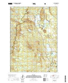
2020 Map of Elk Lake
USGS Topo · Published 2020About this map
Elk Lake sits at the heart of this high-elevation landscape within the Deschutes National Forest and Willamette National Forest. The map documents a complex system of volcanic features and glacial basins along the Cascade Range crest, where numerous water bodies like Hosmer Lake, Doris Lake, and the spring-fed Lava Lake define the terrain. This environment serves as the headwaters for the Deschutes River, which emerges near Little Lava Lake.
Find a feature on this map
55 named features on this map. Tap any name to fly to it.
Don’t see what you’re looking for? This feature index may not catch every label — zoom into the map to look around manually.
Map Details
Editions of this 2020 Elk Lake Map
This is the sole edition of this map. No revisions or reprints were ever made.
Other maps of this area

1929 · Three Sisters
USGS Topo · 1:125,000

1930 · Maiden Peak
USGS Topo · 1:125,000

1932 · Three Sisters
USGS Topo · 1:125,000

1934 · Maiden Peak
USGS Topo · 1:125,000

1955 · Crescent
USGS Topo · 1:250,000

1955 · Bend
USGS Topo · 1:250,000

1957 · Crescent
USGS Topo · 1:250,000

1957 · Bend
USGS Topo · 1:250,000

1958 · Crescent
USGS Topo · 1:250,000

1958 · Bend
USGS Topo · 1:250,000