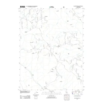
2012 Map of Elk Mountain
USGS Topo · Published 2012About this map
Prather Mill stands as a notable landmark in this 2012 survey of the high country north of the Middle Creek drainage. The landscape is defined by its network of forest service roads and high ridges, including Streeter Ridge and Sled Ridge, which provide access to scattered points of human activity like York Cabin and the small settlement of Enterprise. The terrain is characterized by steep canyons such as Panther Canyon and Grizzly Canyon, where the W Fork Middle Cr and E Fork Middle Cr converge near the Middle Creek Campground.
Find a feature on this map
110 named features on this map. Tap any name to fly to it.
Don’t see what you’re looking for? This feature index may not catch every label — zoom into the map to look around manually.
Map Details
Editions of this 2012 Elk Mountain Map
This is the sole edition of this map. No revisions or reprints were ever made.
Other maps of this area

1920 · Ukiah
USGS Topo · 1:62,500

1922 · Hullville
USGS Topo · 1:62,500

1938 · Lakeport
USGS Topo · 1:62,500

1943 · Pomo
USGS Topo · 1:62,500

1944 · Ukiah
USGS Topo · 1:62,500

1951 · Lake Pillsbury
USGS Topo · 1:62,500

1951 · Lakeport
USGS Topo · 1:62,500

1957 · Ukiah
USGS Topo · 1:250,000

1958 · Cow Mountain
USGS Topo · 1:24,000
1958 · Ukiah
USGS Topo · 1:62,500