
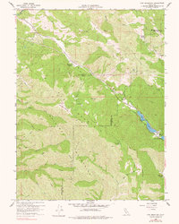
1958 Map of Cow Mountain
USGS Topo · Published 1960About this map
Cow Mountain and the surrounding Mayacmas Mountains dominate this 1958 survey along the Mendocino and Lake County boundary. The landscape is defined by ranching life and rugged watercourses, where isolated homesteads like Lamb Ranch, Hemlock Ranch, and Cow Mountain Ranch are connected by a network of trails and firebreaks. The topography transitions from high peaks such as Shell Peak and the Forty-Acre Opening down into the narrow drainage of Cold Creek. To the east, the terrain breaks at Blue Lakes, with The Narrows and Lower Blue Lake marking a significant geological and recreational boundary in the valley. The presence of numerous named springs, including Black Oak Springs, highlights the critical importance of water management in this upland environment during the late 1950s.
Find a feature on this map
31 named features on this map. Tap any name to fly to it.
Don’t see what you’re looking for? This feature index may not catch every label — zoom into the map to look around manually.
Map Details
Editions of this 1958 Cow Mountain Map
2 editions found
Other maps of this area

1920 · Ukiah
USGS Topo · 1:62,500

1922 · Hullville
USGS Topo · 1:62,500

1938 · Lakeport
USGS Topo · 1:62,500

1943 · Pomo
USGS Topo · 1:62,500

1944 · Ukiah
USGS Topo · 1:62,500

1951 · Lake Pillsbury
USGS Topo · 1:62,500

1951 · Lakeport
USGS Topo · 1:62,500

1957 · Ukiah
USGS Topo · 1:250,000
1958 · Purdys Gardens
USGS Topo · 1:24,000

1958 · Ukiah
USGS Topo · 1:24,000