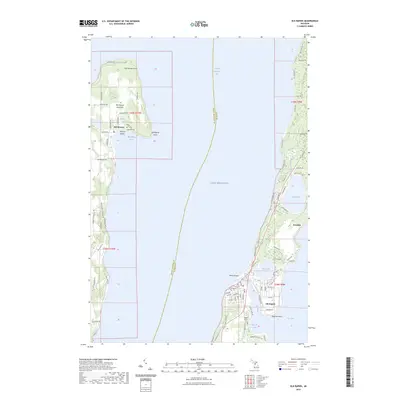
2023 Map of Elk Rapids
USGS Topo · Published 2023About this map
Grand Traverse Bay and Lake Michigan define this coastal landscape, where the Old Mission Peninsula reaches north between the deep waters of the bay's east and west arms. The settlement of Old Mission remains a focal point on the peninsula, featuring the nearby Lakeside Cem and Bagley Lake. Across the water to the east, the village of Elk Rapids sits at a strategic hydraulic junction where the Elk River connects Elk Lake to the Great Lakes. This modern survey illustrates the dense network of local roads and trails, such as Old Mission Road and Joe Marks Trail, that navigate the ridges and lowlands. Between the primary settlements, smaller communities like Kewadin and natural landmarks like Birch Lake and Meguzee Point highlight the established residential and recreational character of the Antrim and Grand Traverse county border.
Find a feature on this map
87 named features on this map. Tap any name to fly to it.
Don’t see what you’re looking for? This feature index may not catch every label — zoom into the map to look around manually.
Map Details
Editions of this 2023 Elk Rapids Map
This is the sole edition of this map. No revisions or reprints were ever made.
Other maps of this area

1954 · Central Lake
USGS Topo · 1:62,500

1954 · Traverse City
USGS Topo · 1:250,000

1955 · Cheboygan
USGS Topo · 1:250,000

1957 · Traverse City
USGS Topo · 1:62,500

1957 · Northport
USGS Topo · 1:62,500

1957 · Elk Rapids
USGS Topo · 1:62,500

1958 · Cheboygan
USGS Topo · 1:250,000

1958 · Traverse City
USGS Topo · 1:250,000

1983 · Omena
USGS Topo · 1:24,000

1983 · Traverse City SE
USGS Topo · 1:25,000
Featured Places
- Peninsula Township, MI
- Elk Rapids, MI
- Elk Rapids Township, MI
- Milton Township, MI
- Torch Lake Township, MI