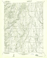
1957 Map of Elk Ridge 4 NE
USGS Topo · Published 1959About this map
Mancos Jim Butte and the Bee Hives dominate this high-desert landscape in the southeastern reaches of the Manti-La Sal National Forest. Surveyed in the mid-1950s, the terrain is defined by dramatic drainage systems including Cottonwood Canyon and Brushy Basin Wash. The map reveals a land utilized for more than just its topography, showing a functional Aqueduct and a Gravel Pit indicative of early infrastructure development in this corner of San Juan County. For the historian or geographer, the prevalence of unnamed seasonal Spring sources and the network of rugged Jeep Tr routes trace the practical movement of people through this remote canyon country before the expansion of more modern road networks. Elevations are meticulously documented, from the heights of Porter VABM 7203 down to the creek beds of Johnson Creek.
Find a feature on this map
19 named features on this map. Tap any name to fly to it.
Don’t see what you’re looking for? This feature index may not catch every label — zoom into the map to look around manually.
Map Details
Editions of this 1957 Elk Ridge 4 NE Map
This is the sole edition of this map. No revisions or reprints were ever made.
Other maps of this area

1886 · Abajo
USGS Topo · 1:250,000

1892 · Abajo
USGS Topo · 1:250,000

1893 · Abajo
USGS Topo · 1:250,000

1935 · Elk Ridge
USGS Topo · 1:96,000

1940 · Elk Ridge
USGS Topo · 1:125,000

1954 · Elk Ridge 4 NW
USGS Topo · 1:24,000

1954 · Elk Ridge 1 SW
USGS Topo · 1:24,000

1954 · Elk Ridge 1 SE
USGS Topo · 1:24,000
1954 · Mt Linnaeus
USGS Topo · 1:62,500

1956 · Cortez
USGS Topo · 1:250,000