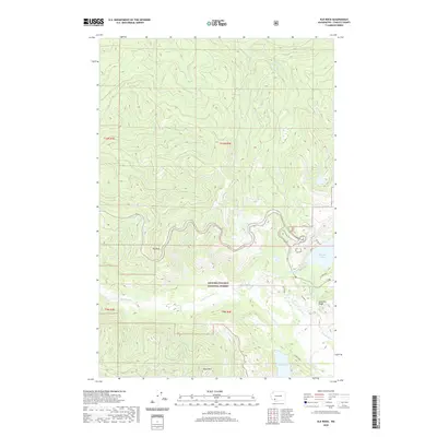
2020 Map of Elk Rock
USGS Topo · Published 2020About this map
The Gifford Pinchot National Forest dominates this landscape, defined by the transformative path of the N Fork Toutle River. This modern survey documents the complex topography of the Cascades, where significant water bodies like Coldwater Lake and Castle Lake sit amidst an intricate network of drainage systems including Maratta Cr, Castle Cr, and Jackson Cr. The terrain is punctuated by prominent elevations such as Elk Rock and Spud Mtn, alongside the geological features of Johnston Ridge and the Hummocks to the southeast. These features illustrate the dramatic natural history of the region and the enduring influence of the volcanic landscape on local drainage and vegetation patterns. The map provides a precise record of contemporary forest boundaries and access, tracing the rugged contours from Elk Bench down to the river valley floor.
Find a feature on this map
25 named features on this map. Tap any name to fly to it.
Don’t see what you’re looking for? This feature index may not catch every label — zoom into the map to look around manually.
Map Details
Editions of this 2020 Elk Rock Map
This is the sole edition of this map. No revisions or reprints were ever made.
Other maps of this area

1919 · Mount St Helens
USGS Topo · 1:125,000

1953 · Hoquiam
USGS Topo · 1:250,000

1953 · Cougar
USGS Topo · 1:62,500

1953 · Elk Rock
USGS Topo · 1:62,500

1957 · Hoquiam
USGS Topo · 1:250,000

1957 · Spirit Lake
USGS Topo · 1:62,500

1958 · Mt St. Helens
USGS Topo · 1:62,500

1958 · Hoquiam
USGS Topo · 1:250,000

1962 · Hoquiam
USGS Topo · 1:250,000
1975 · Spirit Lake SW
USGS Topo · 1:24,000