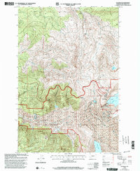
1998 Map of Elk Rock
USGS Topo · Published 2003About this map
The Mount St Helens National Volcanic Monument defines this late-twentieth-century landscape, illustrating a terrain profoundly reshaped by volcanic activity. The map reveals the recovery and management of the area within the Gifford Pinchot National Forest, where the Mud Flow deposits along the North Fork Toutle River serve as a stark reminder of the 1980 eruption. Several newly formed or significantly altered water bodies, including Coldwater Lake and Castle Lake, are central features of the topography, now integrated into the Coldwater Lake Recreation Area.
Find a feature on this map
16 named features on this map. Tap any name to fly to it.
Don’t see what you’re looking for? This feature index may not catch every label — zoom into the map to look around manually.
Map Details
Editions of this 1998 Elk Rock Map
This is the sole edition of this map. No revisions or reprints were ever made.
Other maps of this area

1919 · Mount St Helens
USGS Topo · 1:125,000

1953 · Hoquiam
USGS Topo · 1:250,000

1953 · Cougar
USGS Topo · 1:62,500

1953 · Elk Rock
USGS Topo · 1:62,500

1957 · Hoquiam
USGS Topo · 1:250,000

1957 · Spirit Lake
USGS Topo · 1:62,500

1958 · Mt St. Helens
USGS Topo · 1:62,500

1958 · Hoquiam
USGS Topo · 1:250,000

1962 · Hoquiam
USGS Topo · 1:250,000
1975 · Spirit Lake SW
USGS Topo · 1:24,000