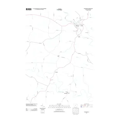
2013 Map of Elkader
USGS Topo · Published 2013About this map
The Turkey River winds through the heart of Elkader, where the notable Keystone Bridge and Elkader Bridge cross its waters. This 2013 survey of Clayton County captures a landscape defined by significant river corridors and the high ground of Chicken Ridge. To the south, the Volga River flows past the small settlement of Mederville, where the Meaderville Bridge and Mederville Access mark a local focal point for river crossing and recreation.
Find a feature on this map
68 named features on this map. Tap any name to fly to it.
Don’t see what you’re looking for? This feature index may not catch every label — zoom into the map to look around manually.
Map Details
Editions of this 2013 Elkader Map
This is the sole edition of this map. No revisions or reprints were ever made.
Other maps of this area

1901 · Oelwein
USGS Topo · 1:125,000

1902 · Elkader
USGS Topo · 1:125,000

1959 · Dubuque
USGS Topo · 1:250,000

1961 · Dubuque
USGS Topo · 1:250,000

1962 · Dubuque
USGS Topo · 1:250,000
1964 · Littleport
USGS Topo · 1:24,000

1964 · Edgewood
USGS Topo · 1:24,000

1964 · Garber
USGS Topo · 1:24,000
1964 · Elkader
USGS Topo · 1:24,000
1965 · Saint Olaf
USGS Topo · 1:24,000