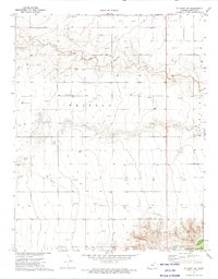
1973 Map of Elkhart NW
USGS Topo · Published 1975About this map
The North Fork Cimarron River winds through the northern reaches of this High Plains landscape, eventually joining the main Cimarron River in the northeast. This 1970s survey illustrates a region defined by extensive energy extraction, with dozens of Gas Wells scattered across the township boundaries of Westola, Jones, and Taloga. The infrastructure of the era is clearly marked by a prominent Pipeline cutting diagonally through the southern sections. While the terrain is predominantly open, the map identifies specific industrial sites such as a Gravel Pit near the southern boundary, reflecting the local resource economy. This record captures the rural character of Morton County just before mid-decade, documenting the precise locations of well heads and river fords that shaped the movement and industry of the local community.
Find a feature on this map
9 named features on this map. Tap any name to fly to it.
Don’t see what you’re looking for? This feature index may not catch every label — zoom into the map to look around manually.
Map Details
Editions of this 1973 Elkhart NW Map
This is the sole edition of this map. No revisions or reprints were ever made.
Other maps of this area

1892 · Vilas
USGS Topo · 1:125,000

1955 · La Junta
USGS Topo · 1:250,000

1955 · Dodge City
USGS Topo · 1:250,000

1958 · La Junta
USGS Topo · 1:250,000

1958 · Dodge City
USGS Topo · 1:250,000

1959 · Dodge City
USGS Topo · 1:250,000

1968 · La Junta
USGS Topo · 1:250,000

1973 · Elkhart NE
USGS Topo · 1:24,000
1973 · Elkhart North
USGS Topo · 1:24,000
1973 · Richfield SW
USGS Topo · 1:24,000