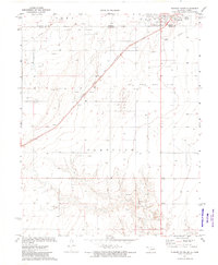
1973 Map of Elkhart South
USGS Topo · Published 1975About this map
The high plains of the Oklahoma Panhandle and southwest Kansas converge at the state line in this early 1970s survey. The landscape is defined by the heavy extraction of natural resources within the Oil and Gas Field and the Carthage and Jones areas. In the northeast corner, the town of Elkhart serves as a regional hub, featuring the Elkhart Municipal Airport and a Golf Course. A Port of Entry marks the crossing into Kansas, while the Atchison Topeka and Santa Fe railroad cuts diagonally across the terrain, passing through small points like Elam and Libbey. Outside the main settlement, the land is dotted with a vast network of oil and gas wells, gravel pits, and service infrastructure such as a Substation and Radio Tower. Cultural landmarks of the era include a Drive-in Theater positioned south of the town center.
Find a feature on this map
18 named features on this map. Tap any name to fly to it.
Don’t see what you’re looking for? This feature index may not catch every label — zoom into the map to look around manually.
Map Details
Editions of this 1973 Elkhart South Map
This is the sole edition of this map. No revisions or reprints were ever made.
Other maps of this area

1892 · Vilas
USGS Topo · 1:125,000

1954 · Perryton
USGS Topo · 1:250,000

1954 · Dalhart
USGS Topo · 1:250,000

1955 · La Junta
USGS Topo · 1:250,000

1955 · Dodge City
USGS Topo · 1:250,000

1958 · Perryton
USGS Topo · 1:250,000

1958 · La Junta
USGS Topo · 1:250,000

1958 · Dodge City
USGS Topo · 1:250,000

1958 · Dalhart
USGS Topo · 1:250,000

1959 · Dodge City
USGS Topo · 1:250,000