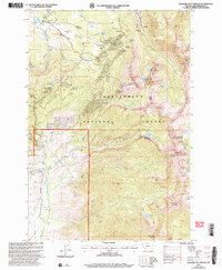
2005 Map of Elkhorn Hot Springs
USGS Topo · Published 2005About this map
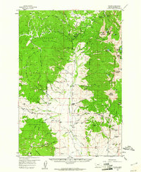
Beaverhead National Forest defines the character of this mountain landscape, which by 2005 remained a rugged intersection of recreational space and old mineral extraction. The small settlement at Elkhorn Hot Springs and the nearby Elkhorn Hot Springs Guard Station stand as central landmarks, while the Pioneer Mountains Scenic Byway provides the primary artery through the high country. Historical mining activity is heavily concentrated in the northeast, where the Old Elkhorn Mine, Park Mine, and the site of Coolidge point to a legacy of hard-rock prospecting. The distribution of high-altitude lakes, including Sawtooth Lake, Anchor Lake, and Polaris Lake, tucked beneath peaks like Comet Mountain and Alturas No 2 Mountain, illustrates a terrain largely shaped by its steep relief. For the historian, the various trails like Wellman Trail and Rubarb Trail branching off from the main roads offer a way to trace the accessibility of these remote timber and mining claims.
Find a feature on this map
65 named features on this map. Tap any name to fly to it.
Don’t see what you’re looking for? This feature index may not catch every label — zoom into the map to look around manually.
Map Details
Editions of this 2005 Elkhorn Hot Springs Map
This is the sole edition of this map. No revisions or reprints were ever made.
Other maps of this area

1893 · Dillon
USGS Topo · 1:250,000
1952 · Torrey Mountain
USGS Topo · 1:24,000
1952 · Ermont
USGS Topo · 1:24,000

1955 · Dillon
USGS Topo · 1:250,000

1957 · Dillon
USGS Topo · 1:250,000

1958 · Dillon
USGS Topo · 1:250,000
1958 · Vipond Park
USGS Topo · 1:62,500
1959 · Polaris
USGS Topo · 1:62,500

1962 · Dillon
USGS Topo · 1:250,000

1965 · Dillon
USGS Topo · 1:250,000