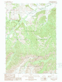
1989 Map of Elkhorn Peak
USGS Topo · Published 1989About this map
Sunlight Creek cuts through the center of this terrain within the Shoshone National Forest, creating a focal point for the isolated drainages and ridges that define the area in the late 1980s. The landscape is dominated by the North Absaroka Wilderness, which covers the northern and southern reaches, separated by the lower-elevation Sunlight Basin. This area is marked by its specialized administrative and recreational infrastructure, notably the Sunlight Ranger Station and various pack trails. The convergence of numerous named drainages like Dead Indian Creek, Gravelbar Creek, and Little Sunlight Creek into the main valley illustrates a complex watershed. High points like Elkhorn Peak and Little Bald Ridge provide structural bounds to the wilderness, while the absence of developed roads highlights the primitive character of the Shoshone back-country.
Find a feature on this map
20 named features on this map. Tap any name to fly to it.
Don’t see what you’re looking for? This feature index may not catch every label — zoom into the map to look around manually.
Map Details
Editions of this 1989 Elkhorn Peak Map
This is the sole edition of this map. No revisions or reprints were ever made.
Other maps of this area

1896 · Crandall Creek
USGS Topo · 1:125,000

1899 · Crandall
USGS Topo · 1:125,000

1949 · Pat O'Hara Mountain
USGS Topo · 1:62,500

1950 · Deep Lake
USGS Topo · 1:62,500

1955 · Cody
USGS Topo · 1:250,000

1956 · Beartooth Butte
USGS Topo · 1:62,500

1956 · Dead Indian Peak
USGS Topo · 1:62,500

1958 · Cody
USGS Topo · 1:250,000

1962 · Cody
USGS Topo · 1:250,000

1980 · Cody
USGS Topo · 1:100,000