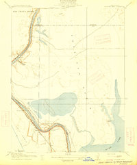
1915 Map of Elkhorn Weir
USGS Topo · Published 1915About this map
The Sacramento River defines the landscape of this survey, serving as the volatile border between Sacramento and Yolo counties before modern flood control reshaped the valley. This 1905 data captures the river's winding course through a series of significant landmarks like Elkhorn Weir and Tenmile Shoals, highlighting the reliance on river crossings at Datey's Ferry near the Taylor Monument. The low-lying terrain is dominated by the American Basin and Yolo Basin, where seasonal waters collected in features like Fisherman's Lake and Tadhunter's Lake. Early settlements and landings, such as Mound Ranch, Marty, and Beatrice, are situated along the riverbanks and the Sacramento Woodland route, providing a window into the agricultural and transportation patterns of the early twentieth-century Sacramento Valley.
Find a feature on this map
23 named features on this map. Tap any name to fly to it.
Don’t see what you’re looking for? This feature index may not catch every label — zoom into the map to look around manually.
Map Details
Editions of this 1915 Elkhorn Weir Map
This is the sole edition of this map. No revisions or reprints were ever made.
Other maps of this area

1891 · Sacramento
USGS Topo · 1:125,000

1892 · Sacramento
USGS Topo · 1:125,000

1893 · Sacramento
USGS Topo · 1:125,000

1902 · Fairoaks
USGS Topo · 1:62,500

1907 · Davisville
USGS Topo · 1:62,500

1910 · Knights Landing
USGS Topo · 1:31,680

1910 · Vernon
USGS Topo · 1:31,680

1910 · Pleasant Grove
USGS Topo · 1:31,680

1911 · Brighton
USGS Topo · 1:31,680

1911 · Arcade
USGS Topo · 1:31,680