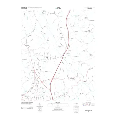
2013 Map of Elkin North
USGS Topo · Published 2013About this map
The Yadkin River forms the southern boundary of this landscape, where the foothills meet the Piedmont. The town of Elkin serves as the primary hub, surrounded by smaller communities such as Elkin Valley, North Elkin, and Poplar Springs. The drainage pattern is defined by the Mitchell River and the S Fork Mitchell River, which flow south toward the Yadkin through a series of small gaps and valleys. Local infrastructure is anchored by the Elkin Municipal Airport and a network of reservoirs and small lakes including Elkin Reservoir, Willowbrook Lake, and Holyfield Lake. Roads like Mulberry Church Rd and Bessies Chapel Church Rd point to the rural social centers of the region. The map captures a mix of residential expansion near the town center and more dispersed agricultural settlements like Zephyr, Mountain Park, and Union Cross to the north.
Find a feature on this map
212 named features on this map. Tap any name to fly to it.
Don’t see what you’re looking for? This feature index may not catch every label — zoom into the map to look around manually.
Map Details
Editions of this 2013 Elkin North Map
This is the sole edition of this map. No revisions or reprints were ever made.
Other maps of this area

1891 · Yadkinville
USGS Topo · 1:125,000

1893 · Yadkinville
USGS Topo · 1:125,000

1953 · Winston-Salem
USGS Topo · 1:250,000

1955 · Winston-Salem
USGS Topo · 1:250,000

1962 · Winston-Salem
USGS Topo · 1:250,000

1966 · Yadkinville
USGS Topo · 1:24,000

1970 · Copeland
USGS Topo · 1:24,000
1971 · Thurmond
USGS Topo · 1:24,000
1971 · Dobson
USGS Topo · 1:24,000
1971 · Elkin South
USGS Topo · 1:24,000