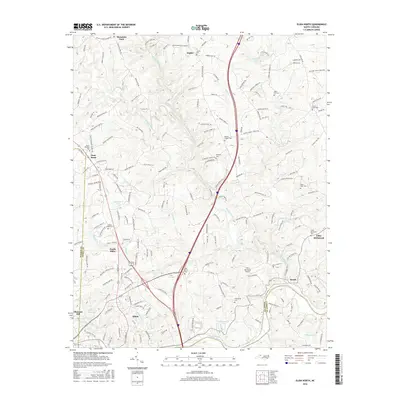
2016 Map of Elkin North
USGS Topo · Published 2016About this map
Elkin and North Elkin anchor this landscape where the Yadkin River meets the southern foothills of the Blue Ridge. The area is defined by its numerous waterways, including the winding Mitchell River and the Elkin Creek drainage, which historically drove the local mills and industrial growth. To the north, the terrain transitions into the more dispersed settlements of Zephyr and Mountain Park, where a high density of rural cemeteries and country churches like Snow Hill Church and Friendship Church suggest a deeply rooted genealogy. The map captures the infrastructure of the mid-2010s, showing the modern alignment of Interstate 77 and the Elkin Municipal Airport alongside older geographic markers like State Road. Researchers can trace the boundaries of Wilkes and Yadkin counties, providing a clear picture of the land ownership and civic layout in this corner of North Carolina.
Find a feature on this map
166 named features on this map. Tap any name to fly to it.
Don’t see what you’re looking for? This feature index may not catch every label — zoom into the map to look around manually.
Map Details
Editions of this 2016 Elkin North Map
This is the sole edition of this map. No revisions or reprints were ever made.
Other maps of this area

1891 · Yadkinville
USGS Topo · 1:125,000

1893 · Yadkinville
USGS Topo · 1:125,000

1953 · Winston-Salem
USGS Topo · 1:250,000

1955 · Winston-Salem
USGS Topo · 1:250,000

1962 · Winston-Salem
USGS Topo · 1:250,000

1966 · Yadkinville
USGS Topo · 1:24,000

1970 · Copeland
USGS Topo · 1:24,000
1971 · Thurmond
USGS Topo · 1:24,000
1971 · Dobson
USGS Topo · 1:24,000
1971 · Elkin South
USGS Topo · 1:24,000