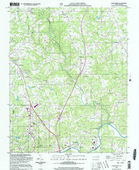
2000 Map of Elkin North
USGS Topo · Published 2003About this map
The Mitchell River carves a deep valley through this portion of Surry County, where the agricultural landscape meets the developing northern outskirts of Elkin. The terrain is marked by a high density of rural community centers, including Zephyr, Mountain Park, and State Road, each anchored by local churches such as Gum Orchard Ch and Poplar Springs Ch. To the south, the expansion of North Elkin and Elkin Valley shows the transition from timbered ridges to more suburbanized layouts near the Wilkes and Surry county line.
Find a feature on this map
52 named features on this map. Tap any name to fly to it.
Don’t see what you’re looking for? This feature index may not catch every label — zoom into the map to look around manually.
Map Details
Editions of this 2000 Elkin North Map
This is the sole edition of this map. No revisions or reprints were ever made.
Other maps of this area

1891 · Yadkinville
USGS Topo · 1:125,000

1893 · Yadkinville
USGS Topo · 1:125,000

1953 · Winston-Salem
USGS Topo · 1:250,000

1955 · Winston-Salem
USGS Topo · 1:250,000

1962 · Winston-Salem
USGS Topo · 1:250,000

1966 · Yadkinville
USGS Topo · 1:24,000

1970 · Copeland
USGS Topo · 1:24,000
1971 · Thurmond
USGS Topo · 1:24,000
1971 · Dobson
USGS Topo · 1:24,000
1971 · Elkin South
USGS Topo · 1:24,000