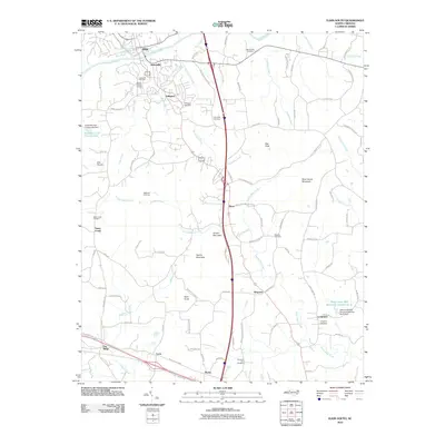
2010 Map of Elkin South
USGS Topo · Published 2010About this map
The Yadkin River separates the towns of Elkin and Jonesville in this 2010 survey of northern Yadkin County. The landscape is defined by its transition from the river valley to the foothills of the Blue Ridge, with prominent peaks like Rock House Mountain, Arnold Mountain, and Hemric Mountain rising above the surrounding agricultural and residential lands. The map details the growing footprint of Arlington and several smaller communities including Rena, Wagoner, and Cycle.
Find a feature on this map
99 named features on this map. Tap any name to fly to it.
Don’t see what you’re looking for? This feature index may not catch every label — zoom into the map to look around manually.
Map Details
Editions of this 2010 Elkin South Map
This is the sole edition of this map. No revisions or reprints were ever made.
Other maps of this area

1891 · Yadkinville
USGS Topo · 1:125,000

1893 · Yadkinville
USGS Topo · 1:125,000

1953 · Winston-Salem
USGS Topo · 1:250,000

1955 · Winston-Salem
USGS Topo · 1:250,000

1962 · Winston-Salem
USGS Topo · 1:250,000
1966 · Lone Hickory
USGS Topo · 1:24,000

1966 · Yadkinville
USGS Topo · 1:24,000

1970 · Copeland
USGS Topo · 1:24,000
1970 · Brooks Crossroads
USGS Topo · 1:24,000
1971 · Thurmond
USGS Topo · 1:24,000