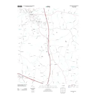
2013 Map of Elkin South
USGS Topo · Published 2013About this map
The Yadkin River defines the northern landscape of this region, separating the industrial and residential centers of Elkin and Jonesville. To the south, the terrain becomes more defined by isolated peaks and ridges, including Hemric Mountain and Rock House Mountain, alongside agricultural features like Highland Orchards. Small communities such as Rena, Wagoner, and Arlington are connected by a network of local roads that branch off from the primary north-south corridors. This 2013 survey illustrates the modern layout of the area, showing the expansion of settlements near Swan Creek Airport and the complex drainage of the river's tributaries, such as S Deep Cr and Sandyberry Cr. The map captures a mix of foothills topography and established town life, providing a clear record of land use and development in this part of Yadkin County.
Find a feature on this map
207 named features on this map. Tap any name to fly to it.
Don’t see what you’re looking for? This feature index may not catch every label — zoom into the map to look around manually.
Map Details
Editions of this 2013 Elkin South Map
This is the sole edition of this map. No revisions or reprints were ever made.
Other maps of this area

1891 · Yadkinville
USGS Topo · 1:125,000

1893 · Yadkinville
USGS Topo · 1:125,000

1953 · Winston-Salem
USGS Topo · 1:250,000

1955 · Winston-Salem
USGS Topo · 1:250,000

1962 · Winston-Salem
USGS Topo · 1:250,000
1966 · Lone Hickory
USGS Topo · 1:24,000

1966 · Yadkinville
USGS Topo · 1:24,000

1970 · Copeland
USGS Topo · 1:24,000
1970 · Brooks Crossroads
USGS Topo · 1:24,000
1971 · Thurmond
USGS Topo · 1:24,000