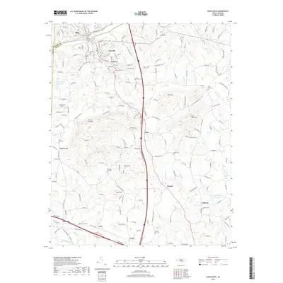
2019 Map of Elkin South
USGS Topo · Published 2019About this map
The Yadkin River defines the northern boundary of this region, separating Elkin in Surry County from Jonesville and Arlington in Yadkin County. The landscape is characterized by the foothills of the Brushy Mountains, where prominent peaks like Arnold Mtn, Hemric Mtn, and Bald Knob rise between the drainages of S Deep Cr and Fall Cr. Modern infrastructure is dominated by the corridor of I-77, which bisects the map from north to south, passing through the community of Rena. Further south, the rural character remains evident in dispersed settlements like Wagoner, Longtown, and Cycle. Genealogists will find several notable burial sites including Island Ford Cem, Jonesville Cem, and Swaims Cem. The map also details the Deep Cr W/S Structure Number Six B, reflecting 20th-century water management efforts in this river-valley landscape.
Find a feature on this map
62 named features on this map. Tap any name to fly to it.
Don’t see what you’re looking for? This feature index may not catch every label — zoom into the map to look around manually.
Map Details
Editions of this 2019 Elkin South Map
This is the sole edition of this map. No revisions or reprints were ever made.
Other maps of this area

1891 · Yadkinville
USGS Topo · 1:125,000

1893 · Yadkinville
USGS Topo · 1:125,000

1953 · Winston-Salem
USGS Topo · 1:250,000

1955 · Winston-Salem
USGS Topo · 1:250,000

1962 · Winston-Salem
USGS Topo · 1:250,000
1966 · Lone Hickory
USGS Topo · 1:24,000

1966 · Yadkinville
USGS Topo · 1:24,000

1970 · Copeland
USGS Topo · 1:24,000
1970 · Brooks Crossroads
USGS Topo · 1:24,000
1971 · Thurmond
USGS Topo · 1:24,000