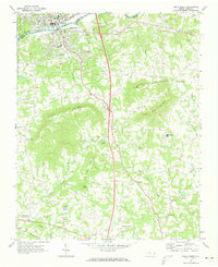
1971 Map of Elkin South
USGS Topo · Published 1973About this map
The Yadkin River defines the northern edge of this North Carolina survey, serving as the historic boundary between Elkin in Surry County and Jonesville in Yadkin County. During the early 1970s, the area shows the transition from the river-and-rail economy of the Southern railroad to modern transit, evidenced by the large cloverleaf at the center of the sheet. To the south, the terrain rises into the Brushy Mountains, where family-named landmarks like Rock House Mountain, Arnold Mtn, and Hemric Mountain dictate the placement of small rural communities. These uplands are dotted with local centers of life such as Swaims Ch, Starmount High Sch, and Mountain Grove Ch, while legacy settlements like Longtown and Wagoner remain anchored along the network of creeks feeding the South Deep Creek.
Find a feature on this map
51 named features on this map. Tap any name to fly to it.
Don’t see what you’re looking for? This feature index may not catch every label — zoom into the map to look around manually.
Map Details
Editions of this 1971 Elkin South Map
This is the sole edition of this map. No revisions or reprints were ever made.
Other maps of this area

1891 · Yadkinville
USGS Topo · 1:125,000

1893 · Yadkinville
USGS Topo · 1:125,000

1953 · Winston-Salem
USGS Topo · 1:250,000

1955 · Winston-Salem
USGS Topo · 1:250,000

1962 · Winston-Salem
USGS Topo · 1:250,000
1966 · Lone Hickory
USGS Topo · 1:24,000

1966 · Yadkinville
USGS Topo · 1:24,000

1970 · Copeland
USGS Topo · 1:24,000
1970 · Brooks Crossroads
USGS Topo · 1:24,000
1971 · Thurmond
USGS Topo · 1:24,000