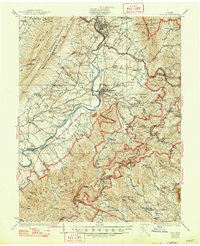
1937 Map of Elkton
USGS Topo · Published 1947About this map
Massanutten Mountain and the Shenandoah River define this 1930s landscape, captured just as the Shenandoah National Park and George Washington National Forest were reshaping the region. The map documents a transition from an agrarian and industrial river valley to a federally managed wilderness, showing Skyline Drive traversing the eastern ridges. Along the South Fork Shenandoah River, the infrastructure of the era is visible at the Harrisonburg Power Plant and the rail corridors of the Norfolk and Western and Chesapeake and Western. For local historians, the sheet preserves a dense network of mountain communities and institutions, including the Blue Ridge Industrial School, the Simmons Gap Mission, and numerous rural schoolhouses like Dovel Sch and Rocky Bar Sch that served the area before larger consolidations.
Find a feature on this map
167 named features on this map. Tap any name to fly to it.
Don’t see what you’re looking for? This feature index may not catch every label — zoom into the map to look around manually.
Map Details
Editions of this 1937 Elkton Map
3 editions found

Other maps of this area

1892 · Woodstock
USGS Topo · 1:125,000

1892 · Gordonsville
USGS Topo · 1:125,000

1892 · Harrisonburg
USGS Topo · 1:125,000

1893 · Luray
USGS Topo · 1:125,000

1905 · Luray
USGS Topo · 1:125,000

1929 · Stony Man
USGS Topo · 1:48,000

1930 · Madison
USGS Topo · 1:48,000

1931 · University
USGS Topo · 1:62,500

1933 · Stony Man
USGS Topo · 1:62,500

1933 · Madison
USGS Topo · 1:62,500