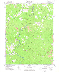
1977 Map of Ellamore
USGS Topo · Published 1977About this map
The Middle Fork River carves a winding path through this central West Virginia landscape, serving as a primary corridor for early transit and settlement. Small communities like Ellamore, Sand Run, and Midvale are positioned along the river's bends and the now-labeled Abandoned railroad lines that once powered the local economy. The landscape is heavily defined by extractive industry, evidenced by numerous Strip Mine operations and a dense network of gas wells scattered across the ridges.
Find a feature on this map
49 named features on this map. Tap any name to fly to it.
Don’t see what you’re looking for? This feature index may not catch every label — zoom into the map to look around manually.
Map Details
Editions of this 1977 Ellamore Map
2 editions found
Other maps of this area

1886 · St. George
USGS Topo · 1:125,000

1889 · Beverly
USGS Topo · 1:125,000

1891 · St. George
USGS Topo · 1:125,000

1892 · Beverly
USGS Topo · 1:125,000

1893 · Buckhannon
USGS Topo · 1:125,000

1896 · Buckhannon
USGS Topo · 1:125,000

1897 · Buckhannon
USGS Topo · 1:125,000

1904 · Philippi
USGS Topo · 1:62,500

1907 · Belington
USGS Topo · 1:62,500

1909 · Elkins
USGS Topo · 1:62,500