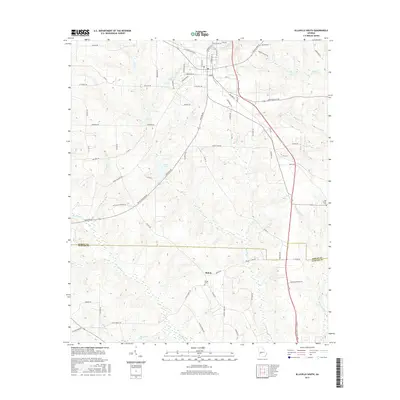
2017 Map of Ellaville South
USGS Topo · Published 2017About this map
The boundary between Schley and Sumter Counties bisects this rural landscape just south of the settlement of Shiloh. The area is defined by a dense network of tributaries, including Muckalee Creek, Deer Creek, and Potcover Creek, which carve through the terrain south of the Ellaville vicinity. In the southern portion of the sheet, the Shiloh Cemetery sits near the junction of Shiloh Road and Moore Road, serving as a central point for local genealogy. To the east, Oak Grove Cemetery overlooks Packers Mill Creek. The landscape is dotted with small bodies of water like Theus Lake and Jorden Lake, while various family-named routes such as Lasco Harvey Road, Napolean Aldridge Road, and Marvin Murphy Road indicate the established agricultural and residential patterns of this Georgia corridor.
Find a feature on this map
77 named features on this map. Tap any name to fly to it.
Don’t see what you’re looking for? This feature index may not catch every label — zoom into the map to look around manually.
Map Details
Editions of this 2017 Ellaville South Map
This is the sole edition of this map. No revisions or reprints were ever made.
Other maps of this area

1955 · Phenix City
USGS Topo · 1:250,000

1957 · Phenix City
USGS Topo · 1:250,000

1958 · Phenix City
USGS Topo · 1:250,000

1971 · Ideal South
USGS Topo · 1:24,000

1971 · Ellaville North
USGS Topo · 1:24,000

1971 · Tazewell South
USGS Topo · 1:24,000

1972 · Ellaville South
USGS Topo · 1:24,000
1972 · Andersonville
USGS Topo · 1:24,000
1973 · Americus
USGS Topo · 1:24,000
1973 · Plains
USGS Topo · 1:24,000