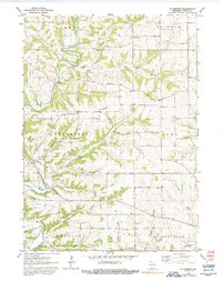
1962 Map of Ellenboro
USGS Topo · Published 1992About this map
Platte River meanders through a landscape of deeply carved valleys and prominent high points like Buckwheat Ridge. The settlement of Ellenboro sits along the river's edge, serving as a focal point for a rural economy defined by township boundaries like Ellenboro, Lima, and Harrison. This 1962 field-checked survey preserves the layout of a mid-century farming community, where social life centered on numerous country schools such as Henry Sch, Union Sch, and White Sch. A high density of family and community burial grounds, including Buckwheat Ridge Cem and Fairview Cem, provides significant data for genealogists tracing local lineage. The drainage pattern is remarkably intricate, with numerous named tributaries like Bull Branch, Bacon Branch, and Willow Branch feeding the larger river systems. The map even captures specific agricultural details, using fine red dashed lines to denote fence and field lines visible from 1958 aerial photography.
Find a feature on this map
31 named features on this map. Tap any name to fly to it.
Don’t see what you’re looking for? This feature index may not catch every label — zoom into the map to look around manually.
Map Details
Editions of this 1962 Ellenboro Map
2 editions found
Other maps of this area

1900 · Lancaster
USGS Topo · 1:125,000

1902 · Mineral Point
USGS Topo · 1:125,000

1904 · Lancaster
USGS Topo · 1:125,000

1908 · Lancaster
USGS Topo · 1:125,000

1952 · Platteville
USGS Topo · 1:24,000

1952 · Rewey
USGS Topo · 1:24,000

1952 · Montfort
USGS Topo · 1:24,000

1957 · Potosi
USGS Topo · 1:24,000

1959 · Dubuque
USGS Topo · 1:250,000

1961 · Dubuque
USGS Topo · 1:250,000