1970 Map of Ellendale
USGS Topo · Published 1973About this map
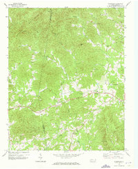
Brushy Mountains dominate the northern terrain of this 1970s topographical record, providing a rugged backdrop to the rural communities of Alexander County. The small settlement of Ellendale sits central to a network of winding secondary roads, while All Healing Springs marks a specific point of interest to the east. The landscape is defined by its watercourses, notably the Middle Little River and its various tributaries like Duck Creek and Beaver Creek.
Find a feature on this map
30 named features on this map. Tap any name to fly to it.
Don’t see what you’re looking for? This feature index may not catch every label — zoom into the map to look around manually.
Map Details
Editions of this 1970 Ellendale Map
This is the sole edition of this map. No revisions or reprints were ever made.
Other maps of this area

1889 · Wilkesboro
USGS Topo · 1:125,000

1891 · Wilkesboro
USGS Topo · 1:125,000

1895 · Hickory
USGS Topo · 1:125,000

1953 · Charlotte
USGS Topo · 1:250,000

1953 · Winston-Salem
USGS Topo · 1:250,000

1954 · Charlotte
USGS Topo · 1:250,000

1955 · Winston-Salem
USGS Topo · 1:250,000

1960 · Charlotte
USGS Topo · 1:250,000

1962 · Winston-Salem
USGS Topo · 1:250,000

1962 · Charlotte
USGS Topo · 1:250,000