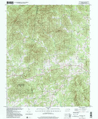
1997 Map of Ellendale
USGS Topo · Published 2000About this map
Brushy Mountains State Game Land dominates the rugged southern terrain of this Alexander County quadrangle, where the Middle Little River winds through the valley floor. The map highlights a rural landscape defined by historic mountain communities such as Ellendale and All Healing Springs, the latter a name suggesting the area's geological and social history. The density of small congregations, including Oxford Memorial Ch, Antioch Ch, and Dover Ch, provides clear data points for genealogists tracking family roots in Barrett Township. High peaks like Never Mtn and Hickory Knob frame a network of drainages such as Lambert Creek and Holsclaw Creek, while a Quarry near the center of the sheet indicates the local extractive industry that shaped the economy alongside the timber and game lands of the Brushy Mountains.
Find a feature on this map
29 named features on this map. Tap any name to fly to it.
Don’t see what you’re looking for? This feature index may not catch every label — zoom into the map to look around manually.
Map Details
Editions of this 1997 Ellendale Map
This is the sole edition of this map. No revisions or reprints were ever made.
Other maps of this area

1889 · Wilkesboro
USGS Topo · 1:125,000

1891 · Wilkesboro
USGS Topo · 1:125,000

1895 · Hickory
USGS Topo · 1:125,000

1953 · Charlotte
USGS Topo · 1:250,000

1953 · Winston-Salem
USGS Topo · 1:250,000

1954 · Charlotte
USGS Topo · 1:250,000

1955 · Winston-Salem
USGS Topo · 1:250,000

1960 · Charlotte
USGS Topo · 1:250,000

1962 · Winston-Salem
USGS Topo · 1:250,000

1962 · Charlotte
USGS Topo · 1:250,000