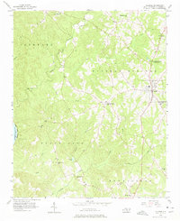
1956 Map of Ellerbe
USGS Topo · Published 1975About this map
The town of Ellerbe serves as a central hub on this mid-century survey of Richmond County, where the landscape transitions from the agricultural flats of the east to the more dissected terrain of the Mineral Springs and Black Jack regions. This 1950s documentation shows a dense network of rural community centers, particularly noted by the frequency of local congregations such as New Hope Ch, Saron Ch, and Mount Pleasant Ch. To the west, the Pee Dee River and the northern tip of Blewett Falls Lake define the border, with numerous watercourses like Big Mountain Creek and Naked Creek draining toward the river basin.
Find a feature on this map
34 named features on this map. Tap any name to fly to it.
Don’t see what you’re looking for? This feature index may not catch every label — zoom into the map to look around manually.
Map Details
Editions of this 1956 Ellerbe Map

Other maps of this area

1942 · Troy
USGS Topo · 1:125,000

1942 · Rockingham
USGS Topo · 1:125,000

1949 · Millstone Lake
USGS Topo · 1:24,000

1949 · Hamlet
USGS Topo · 1:24,000

1949 · Hamlet
USGS Topo · 1:62,500

1949 · Jackson Springs
USGS Topo · 1:62,500

1950 · Norman
USGS Topo · 1:24,000

1953 · Florence
USGS Topo · 1:250,000

1953 · Raleigh
USGS Topo · 1:250,000

1954 · Florence
USGS Topo · 1:250,000