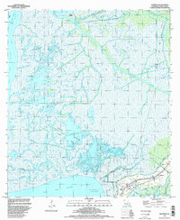
1994 Map of Ellerslie
USGS Topo · Published 1998About this map
West Cote Blanche Bay and East Cote Blanche Bay define this coastal landscape, where the marshy terrain of St. Mary Parish is crisscrossed by an intricate network of natural bayous and industrial canals. The mapping reflects a region heavily defined by petroleum extraction, as seen in the expansive Garden City Gas and Oil Field and the Carlin Gas Field. Transportation and water management are central to the area's layout, with the Intracoastal Waterway cutting through the wetlands and a Road on Levee providing land access to the small settlements of Ellerslie and South Bend. The hydrology is complex, featuring named waterways like Black Crook Bayou and Yellow Bayou alongside artificial channels such as Thorguson Canal. This 1990s survey also notes the presence of a Pumping Station and various drill holes, illustrating the ongoing infrastructure required to maintain and utilize this subsidence-prone coastal environment.
Find a feature on this map
39 named features on this map. Tap any name to fly to it.
Don’t see what you’re looking for? This feature index may not catch every label — zoom into the map to look around manually.
Map Details
Editions of this 1994 Ellerslie Map
This is the sole edition of this map. No revisions or reprints were ever made.
Other maps of this area

1935 · Belle Isle
USGS Topo · 1:31,680

1937 · Bayou Sale
USGS Topo · 1:62,500

1937 · Jeanerette
USGS Topo · 1:62,500

1941 · Belle Isle
USGS Topo · 1:62,500

1945 · New Orleans
USGS Topo · 1:250,000

1948 · Foster
USGS Topo · 1:62,500
1951 · Lake Point
USGS Topo · 1:24,000

1954 · Jeanerette
USGS Topo · 1:62,500

1954 · Belle Isle
USGS Topo · 1:62,500

1957 · Bayou Sale
USGS Topo · 1:62,500