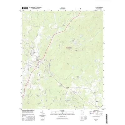
2017 Map of Ellijay
USGS Topo · Published 2017About this map
The Ellijay River and Cartecay River converge in this north Georgia mountain landscape, forming the headwaters of the Coosawattee River. In the early 21st century, the area around Ellijay and East Ellijay serves as a critical junction for both water and road travel, with the Charles Soule Bridge crossing the river near the town center. To the east, the Chattahoochee National Forest encompasses high ground such as Walnut Mtn and Owltown Mtn. Small communities like Oak Hill, Northcutt, and Cartecay are documented through their respective church and cemetery sites, including the Oak Hill United Methodist Church Cem and Turniptown Baptist Church Cem. Numerous small lakes, such as Logan Lake and Clotfelter Lake, are interspersed throughout the ridges, reflecting the region's managed water resources and residential development patterns.
Find a feature on this map
143 named features on this map. Tap any name to fly to it.
Don’t see what you’re looking for? This feature index may not catch every label — zoom into the map to look around manually.
Map Details
Editions of this 2017 Ellijay Map
This is the sole edition of this map. No revisions or reprints were ever made.
Other maps of this area

1886 · Dalton
USGS Topo · 1:125,000

1888 · Ellijay
USGS Topo · 1:125,000

1892 · Ellijay
USGS Topo · 1:125,000

1892 · Dalton
USGS Topo · 1:125,000

1897 · Dalton
USGS Topo · 1:125,000

1898 · Ellijay
USGS Topo · 1:125,000

1911 · Ellijay
USGS Topo · 1:125,000

1911 · Cohutta Mtn
USGS Topo · 1:62,500

1913 · Cohutta Mtn.
USGS Topo · 1:62,500

1914 · Talking Rock
USGS Topo · 1:62,500