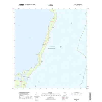
2018 Map of Elliott Key
USGS Topo · Published 2018About this map
Elliott Key and its surrounding archipelago anchor this detailed coastal survey within Biscayne National Park. This portion of the Florida Keys reveals a landscape defined by narrow limestone islands and intricate tidal waterways, including the southern reaches of the Intracoastal Waterway and the sheltered expanse of Biscayne Bay. Near the southern end of the sheet, the community of Islandia is situated among a cluster of smaller islands like Old Rhodes Key and Adams Key. The transition between the bay and the open Atlantic Ocean is marked by tidal passages such as Caesar Creek and Sands Cut. Mariners and historians can trace the underwater geography of the barrier reef system, where features like Ajax Reef and Bache Shoal provide a natural buffer for the inner lagoon and the complex network of points including Log Point and Billys Point.
Find a feature on this map
39 named features on this map. Tap any name to fly to it.
Don’t see what you’re looking for? This feature index may not catch every label — zoom into the map to look around manually.
Map Details
Editions of this 2018 Elliott Key Map
This is the sole edition of this map. No revisions or reprints were ever made.
Other maps of this area
1948 · Soldier Key
USGS Topo · 1:24,000
1949 · Elliott Key
USGS Topo · 1:24,000
1949 · Card Sound
USGS Topo · 1:24,000
1949 · Pacific Reef
USGS Topo · 1:24,000
1949 · Arsenicker Keys
USGS Topo · 1:24,000
1949 · Perrine
USGS Topo · 1:24,000
1956 · Card Sound
USGS Topo · 1:24,000
1956 · Pacific Reef
USGS Topo · 1:24,000
1956 · Elliott Key
USGS Topo · 1:24,000
1956 · Perrine
USGS Topo · 1:24,000