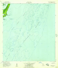
1956 Map of Pacific Reef
USGS Topo · Published 1957About this map
Old Rhodes Key and Totten Key anchor the northwestern corner of this maritime chart, where the land transitions into the shallow, coral-strewn waters of the northern Florida Keys. The topography is dominated by the submarine features of the Atlantic Ocean, meticulously documented via soundings and depth curves compiled by the U.S. Coast and Geodetic Survey. The map captures the hazardous navigation of the mid-1950s, highlighting critical aids to mariners such as the Pacific Reef Lighthouse and various Daybeacons. The boundary between Dade Co and Monroe Co cuts through Broad Creek, while the sheltered waters of Turtle Harbor are protected by the natural barriers of Turtle Reef and Pacific Reef. This hydrographic study provides a clear view of the underwater landscape before the expansion of modern marine preserves, focusing on the intricate channels and banks like Old Rhodes Bank that defined the regional seafloor.
Find a feature on this map
15 named features on this map. Tap any name to fly to it.
Don’t see what you’re looking for? This feature index may not catch every label — zoom into the map to look around manually.
Map Details
Editions of this 1956 Pacific Reef Map
2 editions found
Other maps of this area

1947 · Garden Cove
USGS Topo · 1:24,000

1949 · Garden Cove
USGS Topo · 1:24,000

1949 · Elliott Key
USGS Topo · 1:24,000

1949 · Card Sound
USGS Topo · 1:24,000

1949 · Pacific Reef
USGS Topo · 1:24,000

1949 · Arsenicker Keys
USGS Topo · 1:24,000

1956 · Card Sound
USGS Topo · 1:24,000
1956 · Elliott Key
USGS Topo · 1:24,000
1956 · Arsenicker Keys
USGS Topo · 1:24,000

1956 · Miami
USGS Topo · 1:250,000