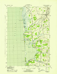
1943 Map of Ellisburg
USGS Topo · Published 1943About this map
Lake Ontario defines the western edge of this coastal Jefferson County landscape, where a complex network of barrier ponds and marshes stretches from Lakeview Pond down to South Pond. The internal drainage system is characterized by meandering waterways like South Sandy Creek and Little Sandy Creek, which feed into the larger coastal basins of North Pond and Sandy Pond. This 1940s survey reveals a rural economy organized around small school districts and country crossroads, with several rural schoolhouses such as School No 11 and School No 13 serving the scattered population. The village of Ellisburg stands as the primary inland settlement, situated at the confluence of several branches of Sandy Creek. Notable local infrastructure includes the Observation Tower overlooking the lake and the historic route of Military Road, which cuts south through the township toward the Jefferson Co Oswego Co line. The map provides a detailed look at the transition from the sandy shoreline to the rising elevation of Colwell Hill.
Find a feature on this map
44 named features on this map. Tap any name to fly to it.
Don’t see what you’re looking for? This feature index may not catch every label — zoom into the map to look around manually.
Map Details
Editions of this 1943 Ellisburg Map
This is the sole edition of this map. No revisions or reprints were ever made.
Other maps of this area

1893 · Sackets Harbor
USGS Topo · 1:62,500

1895 · Sacketts Harbor
USGS Topo · 1:62,500

1895 · Stony Island
USGS Topo · 1:62,500

1895 · Pulaski
USGS Topo · 1:62,500

1942 · Stony Point
USGS Topo · 1:31,680

1942 · Sandy Creek
USGS Topo · 1:24,000

1943 · Henderson
USGS Topo · 1:31,680

1943 · Pulaski
USGS Topo · 1:31,680

1943 · Richland
USGS Topo · 1:31,680

1943 · Texas
USGS Topo · 1:31,680