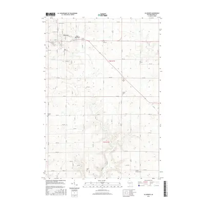
2015 Map of Ellsworth
USGS Topo · Published 2015About this map
Ellsworth and East Ellsworth serve as the primary nodes of development in this Pierce County landscape, where the street grid transitions into a vast network of numbered avenues and country roads. The area is notable for its concentration of rural burial grounds, including Maple Grove Cem, Saint Pauls Cem, and Zion Covenant Cem, which dot the uplands between Isabelle Cr and Lost Cr. This layout reflects a long-established agricultural community where local identity is anchored by these small cemeteries and family-named landmarks like Ulvin Hill. Southward, the terrain shifts into the more dramatic topography of Crystal Springs Coulee, where the drainage patterns of the Driftless Area become more pronounced. Other notable sites include the Old Clayfield Cem and Esdaile Cem, providing valuable points of reference for those tracing regional heritage and land use patterns.
Find a feature on this map
41 named features on this map. Tap any name to fly to it.
Don’t see what you’re looking for? This feature index may not catch every label — zoom into the map to look around manually.
Map Details
Editions of this 2015 Ellsworth Map
This is the sole edition of this map. No revisions or reprints were ever made.
Other maps of this area

1940 · Maiden Rock
USGS Topo · 1:62,500

1944 · Red Wing
USGS Topo · 1:62,500

1946 · River Falls
USGS Topo · 1:62,500

1949 · River Falls
USGS Topo · 1:62,500

1949 · Baldwin
USGS Topo · 1:62,500

1950 · Maiden Rock
USGS Topo · 1:62,500

1952 · Red Wing
USGS Topo · 1:62,500

1953 · Saint Paul
USGS Topo · 1:250,000

1959 · Saint Paul
USGS Topo · 1:250,000
1974 · River Falls East
USGS Topo · 1:24,000