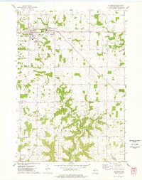
1974 Map of Ellsworth
USGS Topo · Published 1978About this map
The village of Ellsworth and its neighboring community East Ellsworth serve as the hub of this mid-1970s landscape, characterized by the winding path of Isabelle Creek and the surrounding townships of Trimbelle, Ellsworth, and Hartland. The region shows a dense network of local institutions, with several country churches like St Pauls Ch and Zion Covenant Ch serving the dispersed farming community. An interesting industrial footprint is visible through numerous Gravel Pits and a Quarry scattered across the township, reflecting the local geology and road-building needs of the era.
Find a feature on this map
27 named features on this map. Tap any name to fly to it.
Don’t see what you’re looking for? This feature index may not catch every label — zoom into the map to look around manually.
Map Details
Editions of this 1974 Ellsworth Map
This is the sole edition of this map. No revisions or reprints were ever made.
Other maps of this area

1940 · Maiden Rock
USGS Topo · 1:62,500

1944 · Red Wing
USGS Topo · 1:62,500

1946 · River Falls
USGS Topo · 1:62,500

1949 · River Falls
USGS Topo · 1:62,500

1949 · Baldwin
USGS Topo · 1:62,500

1950 · Maiden Rock
USGS Topo · 1:62,500

1952 · Red Wing
USGS Topo · 1:62,500

1953 · Saint Paul
USGS Topo · 1:250,000

1959 · Saint Paul
USGS Topo · 1:250,000
1974 · River Falls East
USGS Topo · 1:24,000