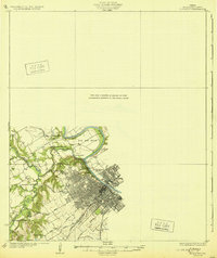
1931 Map of Elm Mott
USGS Topo · Published 1931About this map
The confluence of the North Bosque River and South Bosque River defines the landscape west of Waco, where the combined waters flow toward The Big Bend of the Brazos River. This 1920s-era survey captures the city in a period of significant infrastructure development, evidenced by the emerging street grids of East Waco and McArthur Heights. Early transportation routes such as the Pat M'Neff Highway and the Missouri Kansas Texas RR cut across the drainage of Speegleville Creek, connecting the urban center to rural outposts like Whitehall Ch. The map illustrates the transition from river-crossing economy to highway-oriented growth, preserving the location of early landmarks like the Speegleville Bridge and Cameron Bridge before later hydrological changes altered the river basins.
Find a feature on this map
27 named features on this map. Tap any name to fly to it.
Don’t see what you’re looking for? This feature index may not catch every label — zoom into the map to look around manually.
Map Details
Editions of this 1931 Elm Mott Map
3 editions found
Other maps of this area

1892 · Temple
USGS Topo · 1:125,000

1892 · Waco
USGS Topo · 1:125,000

1920 · Waco
USGS Topo · 1:125,000

1920 · Mart
USGS Topo · 1:62,500

1924 · Waco 4-c
USGS Topo · 1:48,000

1924 · Waco 3-d
USGS Topo · 1:48,000

1931 · Whitney
USGS Topo · 1:62,500

1931 · Valley Mills
USGS Topo · 1:62,500

1931 · Elm Mott
USGS Topo · 1:62,500

1931 · Mc Gregor
USGS Topo · 1:62,500