
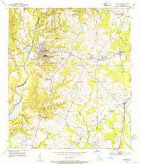
1954 Map of Elm Park
USGS Topo · Published 1955About this map
Audubon Memorial State Park serves as a central landmark in this mid-century survey of the West Feliciana uplands. The landscape is defined by the deep dissection of the terrain by Alexander Creek, Grants Bayou, and Thompson Creek, revealing a rural economy shifting between traditional plantation lands and newer institutional footprints. Large estates like Troy Plantation and Cottage Plantation appear alongside educational and spiritual centers such as the Rosendwald Sch and numerous country churches including Sage Hill Ch and McKowen Ch.
Find a feature on this map
42 named features on this map. Tap any name to fly to it.
Don’t see what you’re looking for? This feature index may not catch every label — zoom into the map to look around manually.
Map Details
Editions of this 1954 Elm Park Map
This is the sole edition of this map. No revisions or reprints were ever made.
Other maps of this area

1906 · Bayou Sara
USGS Topo · 1:125,000

1939 · St. Francisville
USGS Topo · 1:62,500

1939 · Zachary
USGS Topo · 1:62,500

1941 · Lost Creek
USGS Topo · 1:31,680

1945 · Jackson
USGS Topo · 1:31,680

1945 · Lost Creek
USGS Topo · 1:31,680

1953 · New Roads
USGS Topo · 1:24,000

1954 · Zachary
USGS Topo · 1:24,000

1954 · Port Hudson
USGS Topo · 1:24,000
1954 · Jackson
USGS Topo · 1:24,000