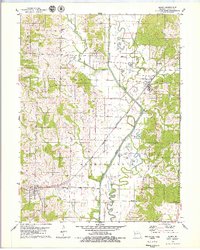
1979 Map of Elmer
USGS Topo · Published 1979About this map
The Chariton River corridor dominates this northern Missouri landscape, showing the dramatic transition between the meandering Old Channel and the straightened modern river course. This hydrological engineering defines the valley, leaving behind oxbow features like Fish Lake, Round Lake, and Bone Yard Lake. The town of Elmer serves as a local hub along the Atchison Topeka and Santa Fe Railroad, which cuts diagonally across the floodplain. To the west, the terrain rises into higher ground at Drake Hill and White Hill, where the settlement of Ethel is situated. The map is a valuable resource for genealogical research, preserving the locations of numerous family-named burial grounds including Glasston Cem, Bunce Cem, and Agee Cem, alongside small rural landmarks like the Star Store.
Find a feature on this map
36 named features on this map. Tap any name to fly to it.
Don’t see what you’re looking for? This feature index may not catch every label — zoom into the map to look around manually.
Map Details
Editions of this 1979 Elmer Map
This is the sole edition of this map. No revisions or reprints were ever made.
Other maps of this area

1937 · Elmer
USGS Topo · 1:48,000

1938 · Kirksville
USGS Topo · 1:62,500

1940 · Kirksville
USGS Topo · 1:62,500

1942 · Elmer
USGS Topo · 1:62,500

1950 · New Cambria West
USGS Topo · 1:24,000

1951 · New Boston
USGS Topo · 1:24,000

1953 · Moberly
USGS Topo · 1:250,000

1954 · Centerville
USGS Topo · 1:250,000

1954 · Moberly
USGS Topo · 1:250,000

1957 · Moberly
USGS Topo · 1:250,000