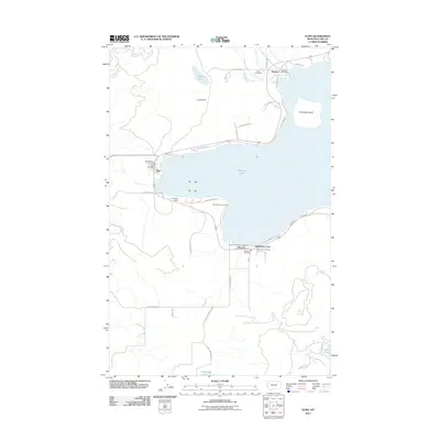
2011 Map of Elmo
USGS Topo · Published 2011About this map
Flathead Lake dominates this 2011 survey, defining the western shoreline and the communities that depend on its waters. The settlements of Dayton, Elmo, and Big Arm are mapped in detail, each maintaining its own civic identity with dedicated post offices and fire departments like the Chief Cliff Vol Fire Dept. The terrain is marked by the dramatic rise of Chief Cliff to the northwest and the presence of Cromwell Island offshore. Local history is evidenced by the Indian Cemetery located near Dayton Creek, while the road network shows a mix of modern infrastructure and older routes like Stage Coach Rd and Hog Heaven Cattle County Rd. Residential and recreational growth is visible through developments like Snowberg Court and the Big Arm Resort and Marina, alongside smaller interior water bodies including Black Lake and Loon Lake.
Find a feature on this map
47 named features on this map. Tap any name to fly to it.
Don’t see what you’re looking for? This feature index may not catch every label — zoom into the map to look around manually.
Map Details
Editions of this 2011 Elmo Map
This is the sole edition of this map. No revisions or reprints were ever made.
Other maps of this area

1920 · Flathead Lake
USGS Topo · 1:125,000

1956 · Wallace
USGS Topo · 1:250,000

1960 · Wallace
USGS Topo · 1:250,000

1964 · Buffalo Bridge
USGS Topo · 1:24,000

1964 · Wild Horse Island
USGS Topo · 1:24,000

1964 · Irvine Lookout Tower
USGS Topo · 1:24,000
1964 · Lake Mary Ronan
USGS Topo · 1:24,000
1964 · Rollins
USGS Topo · 1:24,000

1964 · Elmo
USGS Topo · 1:24,000

1964 · Polson
USGS Topo · 1:24,000