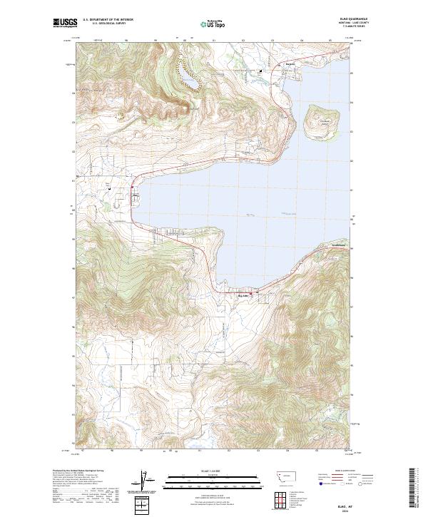
2024 Map of Elmo
USGS Topo · Published 2024About this map
The western shoreline of Big Arm Flathead Lake serves as the focal point for this region, where the steep elevations of the Hog Heaven Range meet the water. The landscape is defined by the massive verticality of Chief Cliff and the presence of Cromwell Island just offshore. Settlements such as Elmo, Dayton, and Big Arm are connected by the corridor of Old US Hwy 93, which follows the natural contours of the bay.
Find a feature on this map
57 named features on this map. Tap any name to fly to it.
Don’t see what you’re looking for? This feature index may not catch every label — zoom into the map to look around manually.
Map Details
Editions of this 2024 Elmo Map
This is the sole edition of this map. No revisions or reprints were ever made.
Other maps of this area

1920 · Flathead Lake
USGS Topo · 1:125,000

1956 · Wallace
USGS Topo · 1:250,000

1960 · Wallace
USGS Topo · 1:250,000

1964 · Buffalo Bridge
USGS Topo · 1:24,000

1964 · Wild Horse Island
USGS Topo · 1:24,000

1964 · Irvine Lookout Tower
USGS Topo · 1:24,000
1964 · Lake Mary Ronan
USGS Topo · 1:24,000
1964 · Rollins
USGS Topo · 1:24,000

1964 · Elmo
USGS Topo · 1:24,000

1964 · Polson
USGS Topo · 1:24,000