
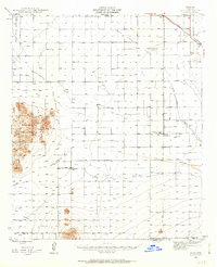
1947 Map of Eloy
USGS Topo · Published 1959About this map
The Santa Cruz River and its accompanying Flats define this Pinal County landscape as it was mapped just after World War II. The settlement at Eloy is shown at a pivotal moment of agricultural and logistical development, anchored by the Southern Pacific Railroad and the proximity of the U S Dept of Agric Farm Labor Camp. The map reveals the early irrigation infrastructure of the region, including the Greens Canal and the already Greens Reservoir (Abandoned), which reflect the challenges of water management in the desert.
Find a feature on this map
19 named features on this map. Tap any name to fly to it.
Don’t see what you’re looking for? This feature index may not catch every label — zoom into the map to look around manually.
Map Details
Editions of this 1947 Eloy Map
2 editions found
Other maps of this area

1922 · Red Rock No 2
USGS Topo · 1:48,000

1922 · Casa Grande
USGS Topo · 1:62,500

1922 · Signal Peak
USGS Topo · 1:62,500

1924 · Signal Peak
USGS Topo · 1:62,500

1924 · Casa Grande
USGS Topo · 1:62,500

1934 · Tucson Mountains
USGS Topo · 1:125,000

1934 · Silver Bell
USGS Topo · 1:125,000

1934 · Newman Peak
USGS Topo · 1:125,000

1942 · Silver Reef Mountains
USGS Topo · 1:62,500

1947 · Red Rock
USGS Topo · 1:62,500