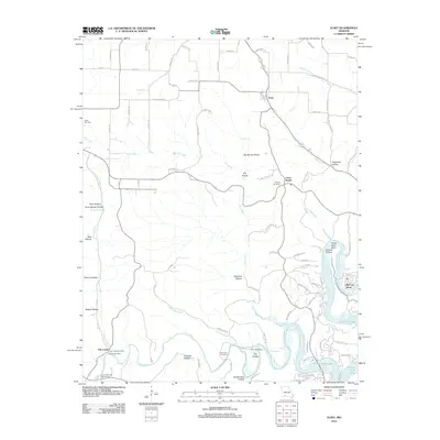
2012 Map of Elsey
USGS Topo · Published 2012About this map
Table Rock Lake dominates the southeastern corner of this Ozark landscape, its shoreline reaching toward McCord Bend and the distinctively shaped Horse-Shoe Bend. The terrain is defined by a dense network of hollows, including Big Spring Hollow, Slickrock Hollow, and Gravelly Hollow, which channel water toward major tributaries like Flat Creek and Carney Creek. This area of Stone County retains a strong rural character, anchored by the community of Elsey and the central junction at Cross Roads. Genealogists will find a concentration of local history markers, including Summers Cemetery, Wilson Cemetery, and Hilton Cemetery. The presence of the Flat Creek Post Office and the Lower Flat Creek Public Access indicates the importance of these waterways and small hubs for local communication and recreation in the early twenty-first century.
Find a feature on this map
93 named features on this map. Tap any name to fly to it.
Don’t see what you’re looking for? This feature index may not catch every label — zoom into the map to look around manually.
Map Details
Editions of this 2012 Elsey Map
This is the sole edition of this map. No revisions or reprints were ever made.
Other maps of this area

1907 · Forsyth
USGS Topo · 1:125,000

1927 · Shell Knob
USGS Topo · 1:62,500

1942 · Aurora
USGS Topo · 1:62,500

1945 · Harrison
USGS Topo · 1:250,000

1945 · Aurora
USGS Topo · 1:62,500

1949 · Harrison
USGS Topo · 1:250,000

1950 · Shell Knob
USGS Topo · 1:62,500

1954 · Harrison
USGS Topo · 1:250,000
1955 · Hurley
USGS Topo · 1:24,000
1956 · Reeds Spring
USGS Topo · 1:24,000