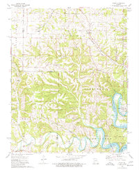
1974 Map of Elsey
USGS Topo · Published 1977About this map
Elsey and the surrounding Stone County hill country appear here in the mid-1970s, defined by the winding course of the James River and the upper reaches of Table Rock Lake. The landscape is a network of ridges and hollows such as Big Spring Hollow and Slickrock Hollow, where small rural communities are anchored by landmarks like Mountain Home Ch and Bowling Chapel Cem. The Missouri Pacific railroad cuts through the northeastern corner near Elsey, tracing the natural contours of the terrain. This period shows a transition in the Ozarks, where traditional river bottomlands like Flat Creek meet the expanding recreational waters of the reservoir, evidenced by several Public Access points along the shoreline. Numerous family cemeteries, including Summers Cem and Noland Cem, provide significant touchstones for genealogical research in this sparsely settled region.
Find a feature on this map
40 named features on this map. Tap any name to fly to it.
Don’t see what you’re looking for? This feature index may not catch every label — zoom into the map to look around manually.
Map Details
Editions of this 1974 Elsey Map
This is the sole edition of this map. No revisions or reprints were ever made.
Other maps of this area

1907 · Forsyth
USGS Topo · 1:125,000

1927 · Shell Knob
USGS Topo · 1:62,500

1942 · Aurora
USGS Topo · 1:62,500

1945 · Harrison
USGS Topo · 1:250,000

1945 · Aurora
USGS Topo · 1:62,500

1949 · Harrison
USGS Topo · 1:250,000

1950 · Shell Knob
USGS Topo · 1:62,500

1954 · Harrison
USGS Topo · 1:250,000
1955 · Hurley
USGS Topo · 1:24,000
1956 · Reeds Spring
USGS Topo · 1:24,000