1918 Map of Elsie
USGS Topo · Published 1918About this map
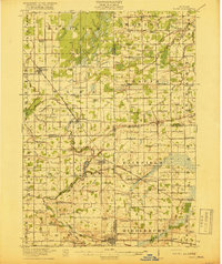
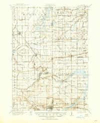
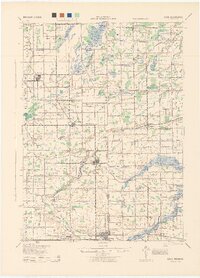
Elsie and the nearby Rochester Colony serve as central hubs in this early twentieth-century survey of the Michigan interior. The landscape is defined by an extensive network of drainage infrastructure, such as the Limbocker Drain and Wait Drain, which supported the region's agricultural development. The Ann Arbor RR and Grand Trunk RR cut through the territory, connecting rural settlements like Bannister and Carland to larger markets. Educational life is highly visible through a dense distribution of one-room schoolhouses, including Elba Center School, Meachem School, and the Christian School. The Maple River meanders across the southern sections, its course punctuated by landmarks like Bradshaw Hill. This map captures a moment when the transition from wetlands to productive farmland was managed through significant local engineering and communal organization.
Find a feature on this map
106 named features on this map. Tap any name to fly to it.
Don’t see what you’re looking for? This feature index may not catch every label — zoom into the map to look around manually.
Map Details
Editions of this 1918 Elsie Map
3 editions found

Historical Maps of Ovid Through Time
Featured Locations
- Ashley, Elba Township
- Chapin, Chapin Township
- Duplain, Duplain Township
- Elsie, Duplain Township
- Ovid, Ovid Township