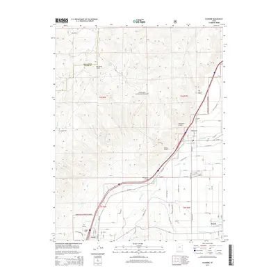
2014 Map of Elsinore
USGS Topo · Published 2014About this map
Elsinore and Monroe anchor this Sevier Valley landscape, where an intricate network of irrigation systems sustains the local agriculture. The Sevier Valley Canal, Richfield Canal, Monroe Canal, and Brooklyn Canal all trace the contours of the valley floor, drawing water from the Sevier River to feed the surrounding fields. This complex water management system defines the settlement patterns between the valley and the rising slopes of the Fishlake National Forest to the west.
Find a feature on this map
59 named features on this map. Tap any name to fly to it.
Don’t see what you’re looking for? This feature index may not catch every label — zoom into the map to look around manually.
Map Details
Editions of this 2014 Elsinore Map
This is the sole edition of this map. No revisions or reprints were ever made.
Other maps of this area

1885 · Beaver
USGS Topo · 1:250,000

1932 · Sevier
USGS Topo · 1:62,500

1935 · Sevier
USGS Topo · 1:62,500

1940 · Monroe
USGS Topo · 1:62,500

1944 · Monroe
USGS Topo · 1:62,500

1953 · Richfield
USGS Topo · 1:250,000

1958 · Richfield
USGS Topo · 1:250,000

1961 · Richfield
USGS Topo · 1:62,500

1962 · Fillmore
USGS Topo · 1:62,500
1980 · Antelope Range
USGS Topo · 1:24,000