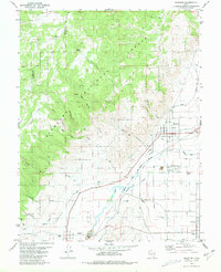
1980 Map of Elsinore
USGS Topo · Published 1981About this map
Elsinore and the neighboring agricultural settlements of Joseph and Monroe sit within the Sevier River valley, anchored by the infrastructure of the Denver and Rio Grande Western railroad. By the late 1970s, the landscape reflected a deeply integrated system of water management, with numerous unnamed Canals branching off the Sevier River to irrigate the broad Joseph Flats. To the west, the terrain rises sharply into the Fishlake National Forest, where steep drainages like Coyote Creek and Albinus Canyon cut through the high ground.
Find a feature on this map
32 named features on this map. Tap any name to fly to it.
Don’t see what you’re looking for? This feature index may not catch every label — zoom into the map to look around manually.
Map Details
Editions of this 1980 Elsinore Map
This is the sole edition of this map. No revisions or reprints were ever made.
Other maps of this area

1885 · Beaver
USGS Topo · 1:250,000

1932 · Sevier
USGS Topo · 1:62,500

1935 · Sevier
USGS Topo · 1:62,500

1940 · Monroe
USGS Topo · 1:62,500

1944 · Monroe
USGS Topo · 1:62,500

1953 · Richfield
USGS Topo · 1:250,000

1958 · Richfield
USGS Topo · 1:250,000

1961 · Richfield
USGS Topo · 1:62,500

1962 · Fillmore
USGS Topo · 1:62,500
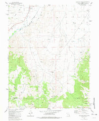
1980 · Antelope Range
USGS Topo · 1:24,000