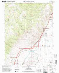
2001 Map of Elsinore
USGS Topo · Published 2003About this map
Sevier Valley acts as the agricultural and industrial heart of this landscape at the dawn of the 21st century, defined by an intricate network of irrigation systems and riverfront settlements. The Sevier River winds through the valley floor, paralleled by vital water infrastructure including the Elsinore Canal, Annabella Canal, and Monroe Canal. These canals supported the growth of clustered communities like Elsinore, Monroe, and Joseph, where human activity meets the rising slopes of the Fish Lake National Forest.
Find a feature on this map
36 named features on this map. Tap any name to fly to it.
Don’t see what you’re looking for? This feature index may not catch every label — zoom into the map to look around manually.
Map Details
Editions of this 2001 Elsinore Map
This is the sole edition of this map. No revisions or reprints were ever made.
Other maps of this area

1885 · Beaver
USGS Topo · 1:250,000

1932 · Sevier
USGS Topo · 1:62,500

1935 · Sevier
USGS Topo · 1:62,500

1940 · Monroe
USGS Topo · 1:62,500

1944 · Monroe
USGS Topo · 1:62,500

1953 · Richfield
USGS Topo · 1:250,000

1958 · Richfield
USGS Topo · 1:250,000

1961 · Richfield
USGS Topo · 1:62,500

1962 · Fillmore
USGS Topo · 1:62,500
1980 · Antelope Range
USGS Topo · 1:24,000