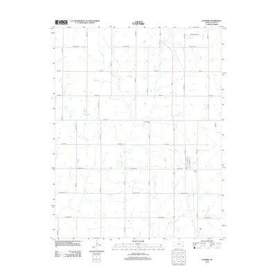
2012 Map of Elsmore
USGS Topo · Published 2012About this map
The agricultural grid of southeastern Allen County defines the landscape around the Elsmore area, where small creeks like Big Cr and Little Cr weave through section lines. Genealogy and local history are anchored by the presence of Old Elsmore Cem and Elsmore Cem, providing specific locations for researchers tracing the early families of this rural Kansas community. The naming convention of the road network is particularly distinctive, with east-west routes named after states such as Maryland Rd, Hawaii Rd, and California Rd, while north-south gravel roads are meticulously numbered. This intersection of state-named roads and surveyed sections creates a highly navigable map for identifying historic homesteads or rural drainage patterns along Mud Cr and Canville Cr during the early 21st century.
Find a feature on this map
29 named features on this map. Tap any name to fly to it.
Don’t see what you’re looking for? This feature index may not catch every label — zoom into the map to look around manually.
Map Details
Editions of this 2012 Elsmore Map
This is the sole edition of this map. No revisions or reprints were ever made.
Other maps of this area

1886 · Iola
USGS Topo · 1:125,000

1893 · Iola
USGS Topo · 1:125,000

1904 · Iola
USGS Topo · 1:125,000

1947 · Joplin
USGS Topo · 1:250,000

1948 · Erie
USGS Topo · 1:62,500

1949 · Erie
USGS Topo · 1:62,500

1949 · Joplin
USGS Topo · 1:250,000
1951 · Chanute
USGS Topo · 1:62,500

1954 · Joplin
USGS Topo · 1:250,000

1958 · Joplin
USGS Topo · 1:250,000