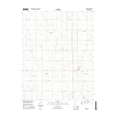
2015 Map of Elsmore
USGS Topo · Published 2015About this map
Elsmore and Savonburg anchor this rural landscape in Allen County, Kansas, where the township and range system is strictly defined by an unusual network of roads named after US states. This grid, including Maryland Rd, Idaho Rd, and California Rd, cuts across the natural drainage patterns of several local waterways. The map documents the courses of Big Cr, Mud Cr, and Little Cr, which meander through the agricultural sections. For those interested in local genealogy, the map identifies two distinct burial sites: Old Elsmore Cem and the more modern Elsmore Cem. The terrain is characterized by gentle elevation changes typical of the region, punctuated by these established community centers and their connecting rural infrastructure.
Find a feature on this map
21 named features on this map. Tap any name to fly to it.
Don’t see what you’re looking for? This feature index may not catch every label — zoom into the map to look around manually.
Map Details
Editions of this 2015 Elsmore Map
This is the sole edition of this map. No revisions or reprints were ever made.
Other maps of this area

1886 · Iola
USGS Topo · 1:125,000

1893 · Iola
USGS Topo · 1:125,000

1904 · Iola
USGS Topo · 1:125,000

1947 · Joplin
USGS Topo · 1:250,000

1948 · Erie
USGS Topo · 1:62,500

1949 · Erie
USGS Topo · 1:62,500

1949 · Joplin
USGS Topo · 1:250,000
1951 · Chanute
USGS Topo · 1:62,500

1954 · Joplin
USGS Topo · 1:250,000

1958 · Joplin
USGS Topo · 1:250,000