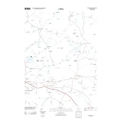
2013 Map of Elverson
USGS Topo · Published 2013About this map
Hopewell Furnace and the surrounding woodlands of French Creek Campground dominate the eastern landscape of this Chester County and Berks County border region. This 2013 survey details a transition from the industrial legacy of the furnace lands toward modern rural and suburban development. The borough of Elverson sits at the center of a drainage network where the E Br Conestoga River and S Br French Cr take shape, marking a significant hydrologic divide. To the northwest, settlements like Geigertown and Scarlets Mill are connected by winding roads through Long Mountain and Trap Rock. Modern transportation infrastructure is prominent, with the Pennsylvania Turnpike Interchange 19 cutting through the southern portion of the quadrangle near Morgantown Crossings, while the Morgantown Airport serves the local aviation needs of the Conestoga valley.
Find a feature on this map
154 named features on this map. Tap any name to fly to it.
Don’t see what you’re looking for? This feature index may not catch every label — zoom into the map to look around manually.
Map Details
Editions of this 2013 Elverson Map
This is the sole edition of this map. No revisions or reprints were ever made.
Other maps of this area

1894 · Reading
USGS Topo · 1:62,500

1902 · Boyertown
USGS Topo · 1:62,500

1905 · Honey Brook
USGS Topo · 1:62,500

1906 · Phoenixville
USGS Topo · 1:62,500

1907 · Honeybrook
USGS Topo · 1:62,500

1913 · Reading
USGS Topo · 1:62,500

1915 · Reading
USGS Topo · 1:62,500

1941 · Honeybrook
USGS Topo · 1:62,500
1943 · Boyertown
USGS Topo · 1:31,680
1943 · Phoenixville
USGS Topo · 1:62,500
Featured Places
- Warwick Township, PA
- East Nantmeal Township, PA
- Elverson, PA
- Cold Run, Robeson Township
- Loag, West Nantmeal Township