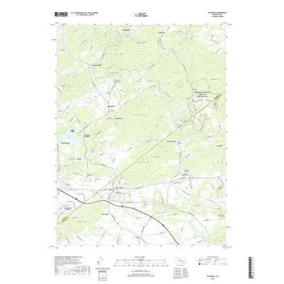
2019 Map of Elverson
USGS Topo · Published 2019About this map
Hopewell Furnace National Historic Site anchors the eastern hills of this landscape, preserving a critical piece of the region's early industrial heritage. The terrain is defined by the high ridges of Welsh Mtn, Long Mtn, and Williams Hill, which overlook a network of small settlements including Elverson, Geigertown, and Warwick. Numerous family and community burial grounds, such as the Saint Pauls United Methodist Church Cem and Rock Church Road Cem, are scattered across the township, offering significant reference points for genealogists. The area is heavily marked by its water resources, with Hopewell Lake, Scotts Run Lake, and the Birdsboro Reservoir providing drainage for the S Br French Cr and Hay Cr. This survey illustrates the transition from rural crossroads to residential clusters, while maintaining large tracts of woodland and preserved parkland.
Find a feature on this map
159 named features on this map. Tap any name to fly to it.
Don’t see what you’re looking for? This feature index may not catch every label — zoom into the map to look around manually.
Map Details
Editions of this 2019 Elverson Map
This is the sole edition of this map. No revisions or reprints were ever made.
Other maps of this area

1894 · Reading
USGS Topo · 1:62,500

1902 · Boyertown
USGS Topo · 1:62,500

1905 · Honey Brook
USGS Topo · 1:62,500

1906 · Phoenixville
USGS Topo · 1:62,500

1907 · Honeybrook
USGS Topo · 1:62,500

1913 · Reading
USGS Topo · 1:62,500

1915 · Reading
USGS Topo · 1:62,500

1941 · Honeybrook
USGS Topo · 1:62,500
1943 · Boyertown
USGS Topo · 1:31,680
1943 · Phoenixville
USGS Topo · 1:62,500
Featured Places
- Warwick Township, PA
- East Nantmeal Township, PA
- Elverson, PA
- Cold Run, Robeson Township
- Loag, West Nantmeal Township